Sky-Level Insights
Precision Drone Services
We provide a comprehensive range of aerial services, including :
-Pet & livestock recovery
- Construction Site Analysis
- Property Orthomosiac Mapping
- Wildlife Aerial Surveys
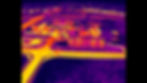
Pet & Livestock Recovery
Are you searching for a reliable way to recover lost pets and livestock? Our cutting-edge thermal drone technology provides a swift and efficient search process. Remember, the sooner you reach out after your pet goes missing the higher the chances of a safe and speedy return. If your furry friend is lost, don't hesitate to contact us anytime 24/7 at 937-553-4535.
Construction Services
Enhance your construction projects with our advanced drone services. Our drones provide comprehensive site analysis, monitor progress in real-time, manage safety protocols, and track equipment efficiently. Experience improved accuracy and efficiency on your construction sites with our cutting-edge technology. Let us help you build a safer and more productive work environment.
Property Orthomosiac Mapping
Transform your property with our cutting-edge unreal technology that captures stunning visuals through thousands of high-resolution photos. These images are expertly stitched together to create a breathtaking map, available in digital format or as unique designs perfect for your hunting cabin or barn. high-definition mapping that outshines Google Earth, tailored for land managers and landowners alike. Discover the progress you've made and the beauty of your land like never before!
Wildlife Aerial Surveys
Unleash the expertise of our certified pilots, who bring hundreds of hours and profound knowledge to every wildlife survey. By leveraging cutting-edge thermal drone technology, we redefine how animal populations are managed and monitored Our dedicated team operates with precision, delivering accurate data for everything from farms to large-scale city analyses. Trust us for impactful insights that drive meaningful results.

Our Vision
Where Innovation Meets Aerial Excellence
Dark Horizon Drones is dedicated to revolutionizing the way people recover, manage, and monitor what matters most through cutting-edge drone technology. We strive to be the trusted leader in aerial solutions, setting the standard for precision, efficiency, and innovation across animal recovery, construction, inspection, and land oversight.


Advantages of Dark Horizon Drones
The Most Advanced Aerial Technology
Our drone technology provides rapid, accurate, and cost-effective solutions that traditional methods can't match. With real-time imaging, thermal sensors, and high-resolution mapping, we deliver precise data and live visuals that enhance your ability to make sound decisions, reduce manual labor, and improve safety. Whether it's locating a lost furry friend or inspecting hard-to-reach structures, our systems offer unmatched speed and efficiency.
Expedited
Fast, Safe, Efficient
Custom
Tailored Aerial Solutions
Precise
Real-Time Surveillance